Duration: (52) ?Subscribe5835 2025-02-12T18:21:31+00:00
ANAFI Aiの自動航行機能を使って3フライト、撮影枚数211枚。後処理はPix4Dmapperを使い点群を生成→3Dモデルを作成→アニメーション機能で動画に。 (撮影約1時間、後処理約2時間)
(52)
ANAFI AI自動航行(空中写真測)ダブルグリッド
(7:14)
3D house modeling in 1 click with ANAFI Ai
(31)
Recreate real life sites in 3D with ANAFI Ai \u0026 @droneharmony
(45)
3D mapping the breathtaking island of Mont Saint-Michel with ANAFI Ai
(30)
Parrot ANAFI Ai Launch Video
(1:47)
[先行レビュー] 格安なのにイロイロ撮れる本格派!スマート望遠鏡の完成形 DWARF 3 〜使い方と作例の紹介〜
(13:21)
The Anafi Ai Drone | Competitive All-in-One Commercial Drone
(22:12)
Parrot Anafi Ai の初見と飛行テスト - 世界初の 4G ドローン!
(6:33)
Parrot Anafi USA First Flight and Impressions - Small But Mighty
(18:14)
Parrot ANAFI USA Comprehensive Review and test
(37:43)
Vorstellung der Parrot Anafi USA Drohne
(14:28)
Parrot Anafi Ai は写真測量やドローン調査に適していますか?
(11:36)
Exploring the New AI 3D Modeling Tool “Tripo AI for Web”! See the Evolution from “TripoSR”!
(14:18)
DJI Mini 2 vs Parrot Anafi
(12:39)
Parrot ANAFI Ai Drone - Overview - The 4G robotic UAV
(6:16)
ANAFI Ai taking off from and landing on a moving vehicle.
(21)
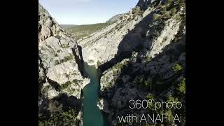
360° photo with ANAFI Ai
Photogrammetry test with Parrot Anafi AI
(2:6)
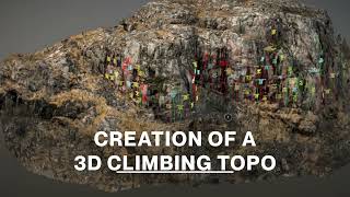
Creation of a 3D climbing topo with ANAFI Ai
(1:10)
ANAFI Ai captures, inspects \u0026 share in a few clicks.
(33)
The future of robotics applied.
(22)
3D Mapping with the Parrot Anafi Thermal and Pix4D
(15)
PARROT ANAFI Ai - THE 4G DRONE 2021 IT'S HERE - LAUNCH VIDEO
(1:58)
Parrot Anafi Ai Testing - How does it compare on Oblique Photogrammetry?
(11:25)
【Flight Simコントローラー】卓上タイプのヘリコプター専用コントローラー製作開始
(59)
ANAFI Ai - 3D mapping of the full city of Positano with a drone
(58)
거대한 도시도 스스로 3D 맵핑 하는 드론 Parrot Anafi Ai
ANAFI Ai - 3D mapping of the tallest gravity dam in the world
(26)
Parrot ANAFI Ai Vertical 3D Mapping Made Easy


![[先行レビュー] 格安なのにイロイロ撮れる本格派!スマート望遠鏡の完成形 DWARF 3 〜使い方と作例の紹介〜](https://ytimg.googleusercontent.com/vi/pKv8byPyYpc/mqdefault.jpg)